
...
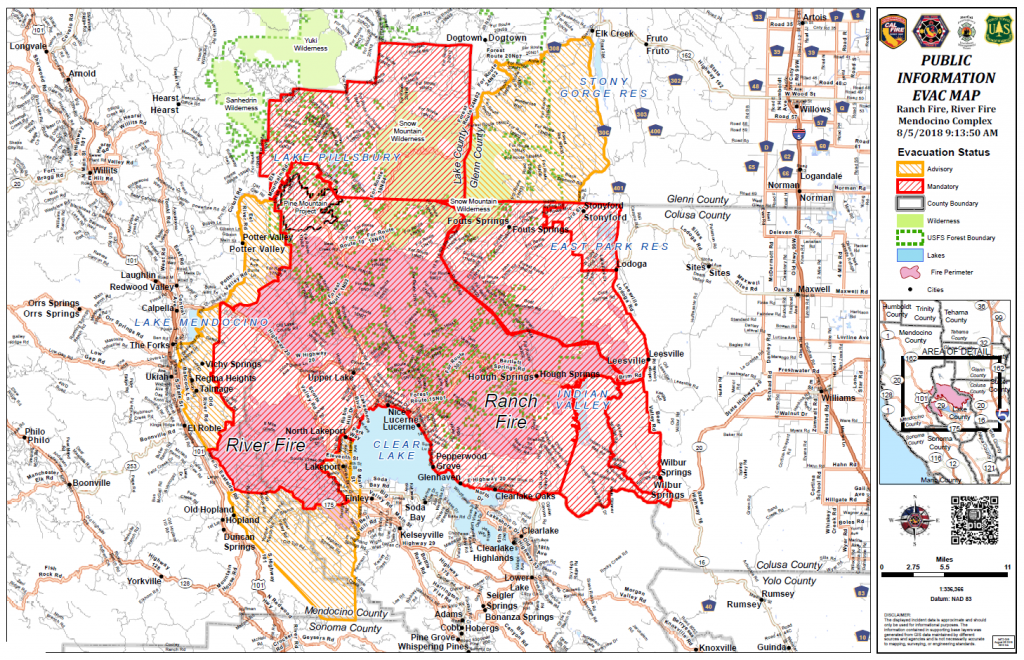
Side by side, fire maps from the same sources for yesterday and today — agencies' Operations Overview maps and the MODIS heat maps — and then, having paid particular attention to the eastern edge of the southern fire, the River Fire, which is on its way to meet the Ranch Fire, compare THIS map from today, posted by Yuba Net, to those.
Look at that eastern edge on all these maps. I can go back and get the huge pdf versions of the Operations Overview maps, but I can assure you they are identical for both yesterday and today, despite having jumped their fire breaks and despite prevailing winds and despite Red Flag weather warnings in effect for both days. I've narrowed it down to these to avoid driving everyone and myself crazy again, but the plain fact is: THEY DON'T UPDATE THE PERIMETER MAPS WHEN THEY DON'T WANT THE PUBLIC TO SEE WHAT'S GOING ON.
Even if they update the rest of the perimeter, they don't update the one directly adjacent to the biggest city in the area. They pulled this on the advance of the Chetco Bar fire last year. Steadily updating maps at most of the usual sites, and mostly in something approximating agreement, until it got close to town. Then suddenly no way to judge for yourself whether to evacuate, or stay evacuated, or hold the fort, or EVEN which of the umpteen versions of fire maps from every source had information closest to accurate.
THIS time the evacuation and repopulation orders are even confusing as fuck.
I don't believe this isn't purposeful.
I don't believe our lives depend on incompetents who prefer totalitarian activity to an informed and even ultimately very helpful citizenry. I'm outraged again. I keep trying not to be.
PUBLIC INFORMATION MAP 8/4/18
OPERATIONS OVERVIEW MAP 8/4/18
...
RHBB COVERAGE FOR 8/5/18
You can note that section of River Fire perimeter is again, identical. I think they have relied on the irrigation systems in the farms and orchards to keep the fire off... and probably plenty firefighters too... or they wouldn't be so neglectful of updating that perimeter where the winds could make the hotspots flare and shoot right through to the lake. North of the heavily irrigated area, however, is ripe for the fire doing just that.
I'm unhappy about the difficulty getting detailed information, but Kym has outdone herself today in getting more auxiliary maps to give an even more comprehensive picture, AND a goddam evacuations map so people can see better what kind of trouble they or their loved ones are in. Without slaving over search engines and coming away with our brains so scrambled we don't know what is hitting us.
As always with Lake County, though, the fear of the fire competes with the fear of looting. They run neck and neck, because the place is what it is. Major drugs. Major crime. Major existential misery. Major fire hazard... all the way around the lake. You are considered a snooty rich person if you live in Lakeport or Kelseyville... when, anywhere else in the state, you would be a member of the great unwashed, along with anyone else worth under about ten million dollars.
The entire population of Scotts Valley, the valley in Lake County, not the town in Santa Cruz County, has been good old fashioned and all-American middle class, who were considered the cream of Lake County residents... in aggregate. I'm not a hunnert percent sure but I think they let them burn, and they will let all the cabins up at Pillsbury burn too. The focus is, for once, actual firefighting — as opposed to the now habitual fire tending with most California wildfires — around the heavily populated areas around the lake.
For the heartless, this is a damn shame. For the decent, it's a mixed blessing. A lot of people have been wanting to turn the entire area into a Lake Tahoe or Las Vegas style gambling mecca, upgrade the almost unbroken squalor around the lake and have some type of powerhouse resort and adult playground instead of this dilapidated hodgepodge. Maybe they will get their chance.
pipe up any time....


